


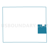
Voting District 0250100000001, Calhoun County, Michigan
About
Outline

Summary
| Unique Area Identifier | 596158 |
| Name | Voting District 0250100000001 |
| County | Calhoun County |
| State | Michigan |
| Area (square miles) | 33.03 |
| Land Area (square miles) | 32.63 |
| Water Area (square miles) | 0.40 |
| % of Land Area | 98.78 |
| % of Water Area | 1.22 |
| Latitude of the Internal Point | 42.19520950 |
| Longtitude of the Internal Point | -84.76343310 |
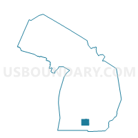
Maps

Graphs
Select a template below for downloading or customizing gragh for Voting District 0250100000001, Calhoun County, Michigan


Neighbors
Neighoring Voting District (by Name) Neighboring Voting District on the Map
- Voting District 0250098000002, Calhoun County, MI
- Voting District 0250098000003, Calhoun County, MI
- Voting District 0250098000005, Calhoun County, MI
- Voting District 0250098000006, Calhoun County, MI
- Voting District 0251602000001, Calhoun County, MI
- Voting District 0252470000001, Calhoun County, MI
- Voting District 0253894000001, Calhoun County, MI
- Voting District 0255152000001, Calhoun County, MI
- Voting District 0257298000001, Calhoun County, MI
- Voting District 0751776000001, Jackson County, MI
- Voting District 0756276000001, Jackson County, MI
- Voting District 0756644000001, Jackson County, MI
Top 10 Neighboring County Subdivision (by Population) Neighboring County Subdivision on the Map
- Albion city, Calhoun County, MI (8,616)
- Homer township, Calhoun County, MI (3,015)
- Parma township, Jackson County, MI (2,726)
- Concord township, Jackson County, MI (2,723)
- Marengo township, Calhoun County, MI (2,213)
- Pulaski township, Jackson County, MI (2,075)
- Sheridan township, Calhoun County, MI (1,936)
- Eckford township, Calhoun County, MI (1,303)
- Clarendon township, Calhoun County, MI (1,139)
- Albion township, Calhoun County, MI (1,123)
Top 10 Neighboring Place (by Population) Neighboring Place on the Map
Top 10 Neighboring Unified School District (by Population) Neighboring Unified School District on the Map
- Albion Public Schools, MI (11,840)
- Concord Community Schools, MI (5,127)
- Homer Community Schools, MI (4,654)
Top 10 Neighboring State Legislative District Lower Chamber (by Population) Neighboring State Legislative District Lower Chamber on the Map
Top 10 Neighboring State Legislative District Upper Chamber (by Population) Neighboring State Legislative District Upper Chamber on the Map
Top 10 Neighboring 111th Congressional District (by Population) Neighboring 111th Congressional District on the Map
Top 10 Neighboring Census Tract (by Population) Neighboring Census Tract on the Map
- Census Tract 64.02, Jackson County, MI (6,995)
- Census Tract 65, Jackson County, MI (6,710)
- Census Tract 38, Calhoun County, MI (4,128)
- Census Tract 64.01, Jackson County, MI (3,223)
- Census Tract 31, Calhoun County, MI (3,015)
- Census Tract 35, Calhoun County, MI (2,675)
- Census Tract 34, Calhoun County, MI (2,359)
- Census Tract 32, Calhoun County, MI (2,334)
- Census Tract 33, Calhoun County, MI (2,221)
- Census Tract 30, Calhoun County, MI (2,125)